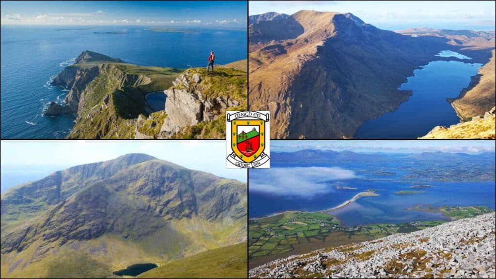
County Mayo boasts a diverse array of impressive mountain ranges and peaks. This guide highlights the ones I believe deserve a prominent place on any hiking itinerary.
From the more popular and heavily trodden trail of Croagh Patrick to the magnificently hidden cliffs of Achill Island, each mountain offers a distinct experience.
We’ll look at 5 of my favourites; these are mountains I have personally hiked and many of which I return to again and again. For me, these offer the most rewarding experience, both in terms of a challenge and the spectacular views they offer from the summit.
The Mountain Ranges of Mayo
In the southwest of the county, the Mweelrea Mountains rise dramatically above Killary Harbour and Doolough Valley, with Mweelrea (814 m) standing as Connaught’s highest peak. To the northwest, the Nephin Beg Range offers a remote and wild wilderness, the most prominent peak being Slieve Carr and forming part of Wild Nephin National Park.
The Partry Mountains, in the southeast near the Galway border, are known for their broad ridges and views over Lough Mask. Nearby, the Sheeffry Hills are a series of high plateau peaks between Westport and Leenane. Across the Glenummera valley, you’ll find the magnificent Ben Gorm and Ben Creggan.
Closer to Clew Bay, Croagh Patrick and its surrounding hills provide both spiritual significance and breathtaking coastal scenery.
Achill boasts 2 peaks of significance, namely Slievemore (671 m) and the peak of Croaghaun (688 m). The north-western side of the latter is heavily eroded, presenting awe-inspiring cliff scenery to rival any coastal landscape in the world.
Now, let’s take a closer look at the mountains I believe offer the most rewarding hiking experiences in County Mayo.
5 Majestic Mountains in Mayo To Climb
Croagh Patrick (764 m)
Location
Murrisk, 8 km west of Westport, on the shores of Clew Bay.
Height
764 metres (8th highest peak in Mayo)
Difficulty
Challenging, although has been made safer since the implementation of natural steps on a large section of the trail.
What makes it iconic?
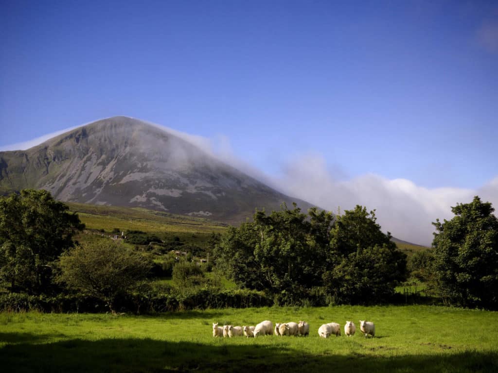
Mayo’s and possibly Ireland’s most well-known mountain, Croagh Patrick aka The Holy Mountain or The Reek has been a place of pilgrimage for centuries. It has links to Saint Patrick, who is said to have fasted on its summit for 40 days in 441 AD. Its history as a sacred site dates back even further to pre-Christian times.
The mountain has a very distinctive pyramid-shaped peak and can be seen and easily recognised from far and wide. It forms a spectacular backdrop to the town of Westport and the unique Clew Bay with its 100s of islands dating back to the ice age. St. Patrick’s chapel is found on its summit and the views are nothing short of breathtaking.
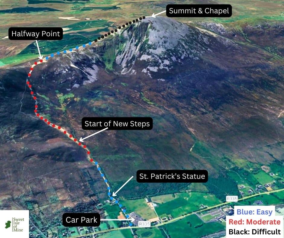
Croagh Patrick Pilgrim Trail Details
The official start of the pilgrim trail is across the road from the car park at Murrisk Abbey, but almost all climbers start from the car park.
A long slog which starts off relatively easily to the statue of St. Patrick. The middle section is moderately challenging which is followed by a long, almost flat section before the last steep ascent (The Cone) to the summit. Total hiking distance: 11.08 km (6.9 miles)
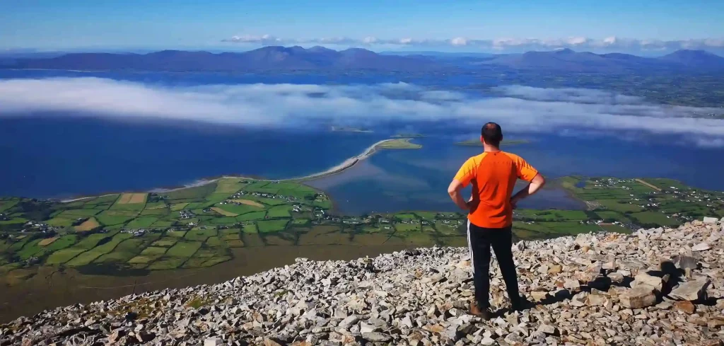
The summit presents unforgettable views over all the 365 islands of Clew Bay, Nephin Beg range, the Sheeffry Hills, Partry Mountains and Connemara. You’re rewarded with coastal views as far as Achill island and Clare Island. Choose a clear day to avoid disappointment.
For an in-depth hiking guide click here.
Croaghaun Cliffs (688 m)
Location
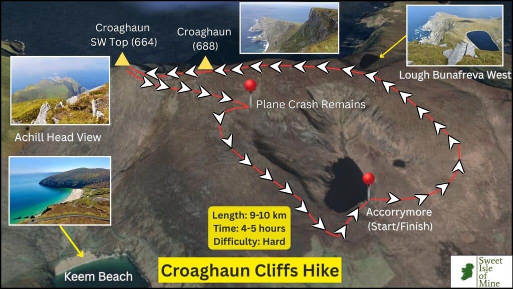
Located on the western end of Achill Island, Croaghaun cliffs are notoriously difficult to access. This is done so only by foot from either Lough Accorrymore or the far more challenging route from Keem Strand.
Height
There are 2 main peaks in the Croaghaun massif, namely Croaghaun (688 m) and Croaghaun South West Top (664 metres)
Difficulty
On the northern shores there are staggering drops into the Atlantic ocean below. The cliffs are accessed from a southwesterly direction. From Keem, the ascent is strenuous: very steep and exposed, whereas the ascent from Accorrymore offers a more moderate, albeit longer challenge.
What makes it iconic?
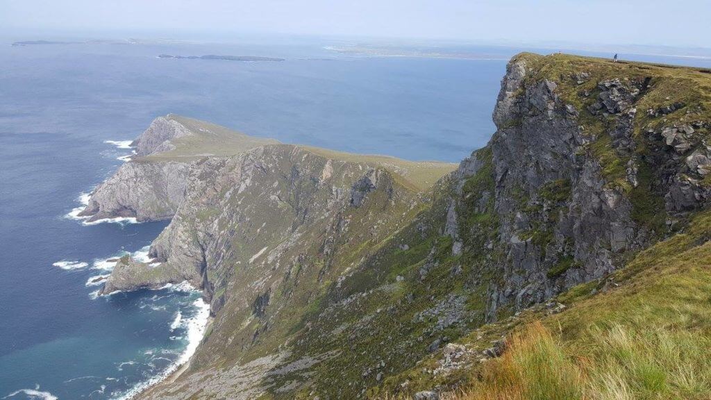
Croaghaun remains largely undiscovered beyond specific groups of hikers who have either summited the mountain or have it prominently on their bucket list. The cliffs can only be viewed from certain vantage points i.e from the sea, from the summit or from Achill & Saddle Head.
Arguably Ireland’s most spectacular coastal landscape, the cliffs are over 3 times higher than the Cliffs of Moher. The landscape is characterised by a variety of geographical features; rocky peaks, exposed quartzite and sheer cliff faces in every direction.
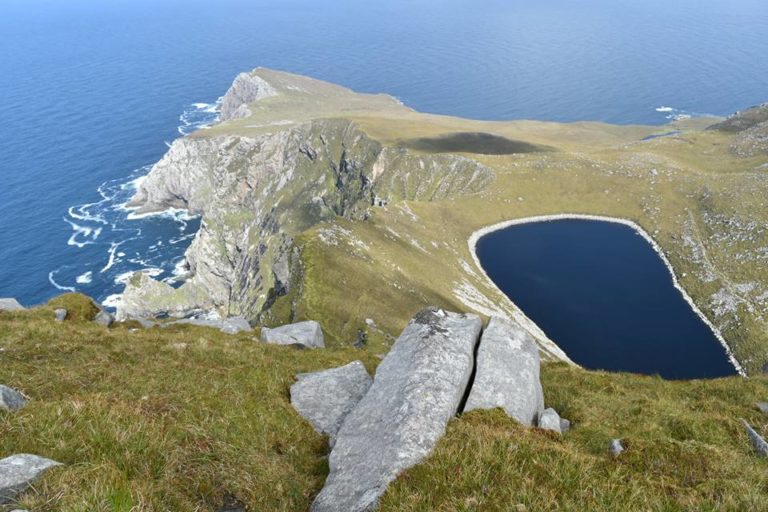
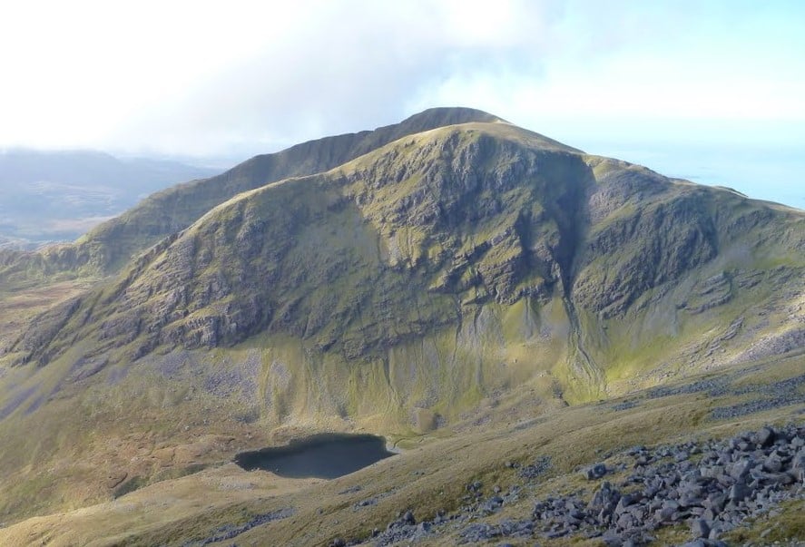
One standout feature among many in the landscape is the ‘suspended’ corrie lake located at Bunnafreva. This crater-like freshwater lake almost defies logic and is widely regarded as Ireland’s most spectacular glacial lake.
Mweelrea/Ben Lugmore/Ben Bury (814 m)
Location
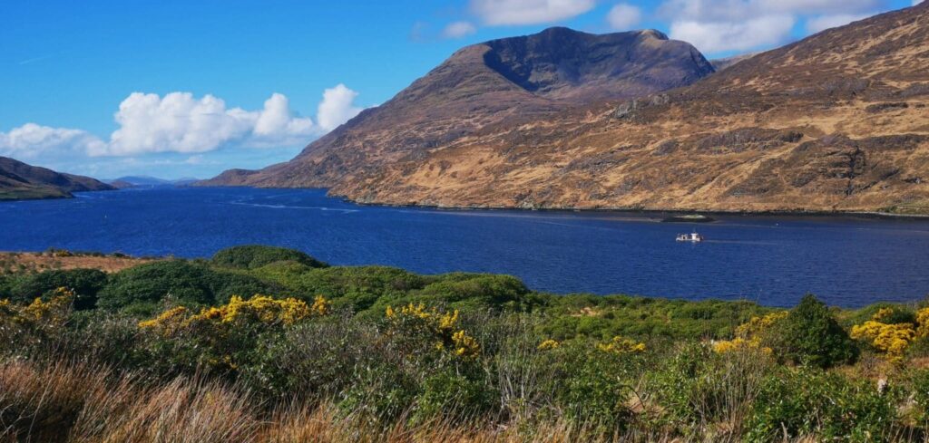
Located in south-west Mayo, the Mweelrea Massif is bordered by Killary Harbour to the south, Ireland’s only fjord, and by the expansive Doo Lough valley to the east. To the west lies Sliver Strand and the Atlantic Ocean.
Height
Standing at 814 meters, the summit of Mweelrea (Irish: Maol Réidh) is the tallest peak in both County Mayo and Connacht. The massif features several notable peaks, with Ben Lugmore (803 m) and Ben Bury (795 m) being among the most prominent.
Difficulty
The ascent via the famous ‘Ramp’ from Doolough is regarded as very challenging due to a steep ascent and also a section of the path which narrows significantly. This can be treacherous in bad weather. Unfortunately, this route has claimed lives in the past and it is highly recommended to only attempt during clear weather and with sufficient hiking experience and fitness.
The route from Silver Strand is regarded as less dangerous but again only during fine, settled weather.
What makes it iconic?
Mweelrea is regarded as the ‘king’ of Mayo mountains for a variety of reasons. Firstly, due to its title as the highest peak in the county, it attracts attention from hikers both far and wide. Added to this, the 360 degree panorama on display from its summit will satisfy even the most avid of hill-walkers.
There are magnificent views of a variety of landforms everywhere you look; Ireland’s only glacial fjord, Killary, Silver and White Strands, Clare and Achill Islands, The Sheeffry Hills, Partry Mountains, The 12 Bens, Croagh Patrick, amongst many more.
Also the sheer scale of the 500 metre vertical rock face looming over you as you ascent from Doolough Valley is worth the challenge alone. There are few mountain landscapes in Ireland to match the splendour and vastness of the north face of Ben Lugmore.
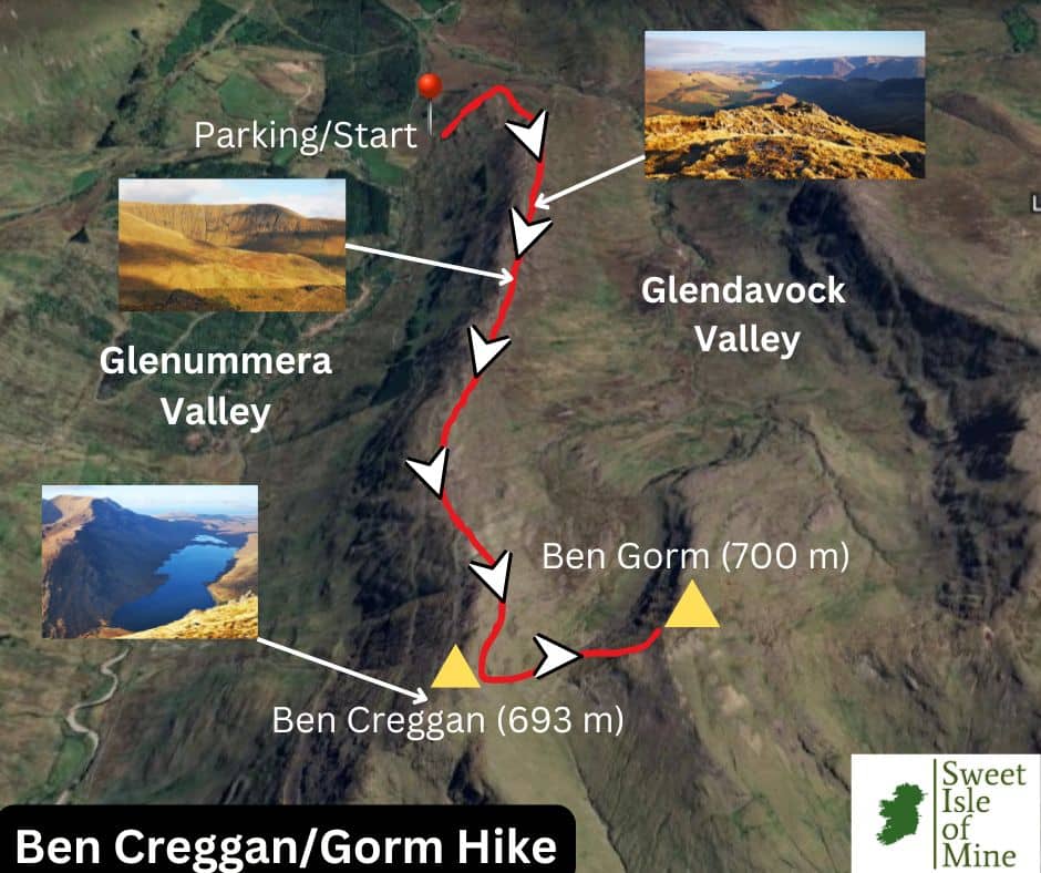
Ben Gorm/Ben Creggan
Location
The peaks Ben Gorm and Ben Creggan are located in the same mountain group in south-western Mayo amongst several unique landscapes. To the south, it overlooks Killary Harbour, Ireland’s only fjord. To the west, Fin Lough and Doo Lough lie between Ben Gorm/Creggan and the Mweelrea Mountains, forming a natural divide.
To the north lies the picturesque Glenummera Valley and this separates the peaks from the majestic Sheeffry Hills (highest peak: Barrclashcame, 772 m), while to the east lies the uninhabited Glendavock Valley
Height
Ben Gorm (An Bhinn Ghorm) reaches a height of exactly 700 metres, while Ben Gorm South Top 687 metres. Ben Creggan (Binn an Charragáin) has an elevation of 693 metres.
Difficulty
Like all mountains in Mayo of any significance Ben Gorm and Ben Creggan are challenging hikes, mainly due to the lack of a clear path to their summits coupled with the steep final ascent. This area is also known for open fault lines which under normal conditions are clearly visible. Although in snowy or foggy conditions, these could be treacherous.
What makes them iconic?
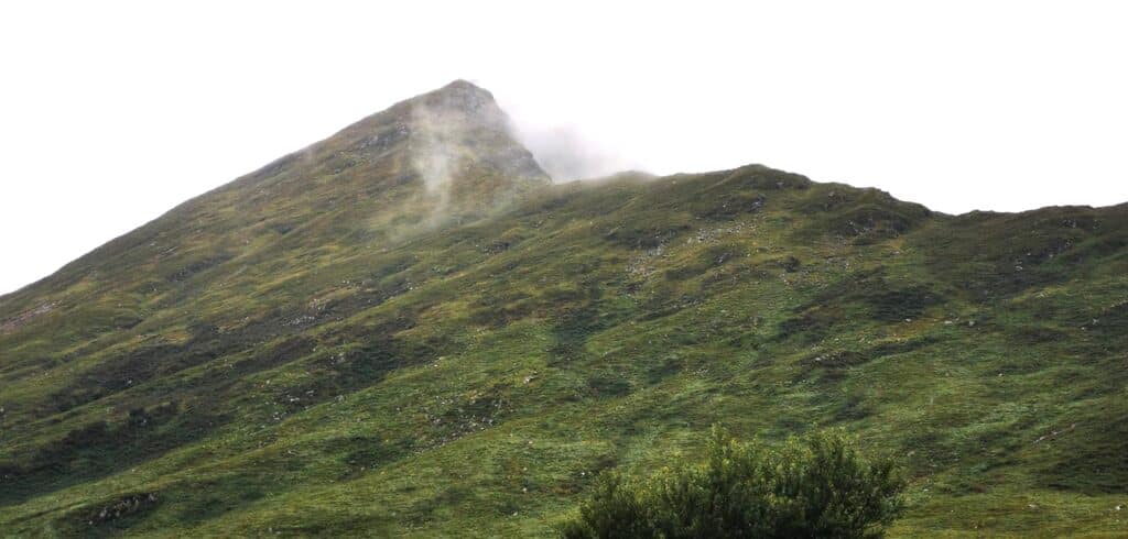
My initial introduction to these mountains was during a day trip through the magnificent nearby Doolough Valley. When passing through from north to south, Ben Creggan’s summit rises steeply above the flat valley floor and looked magnificent, albeit quite intimidating.
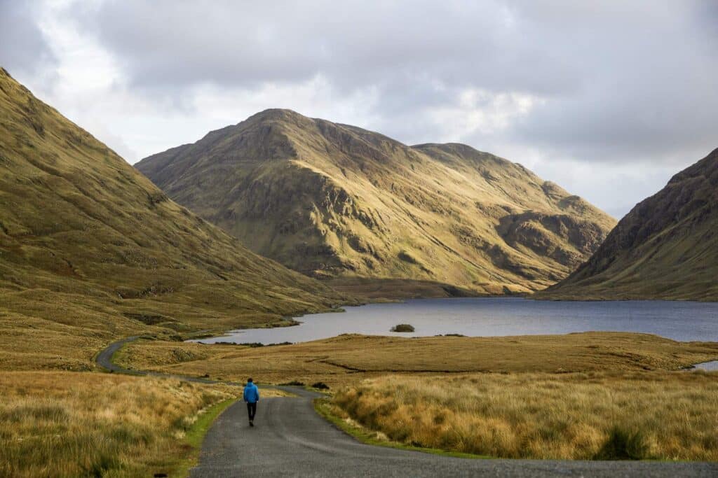
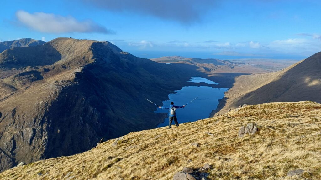
Perhaps one of the biggest reasons hikers choose the walk however is because of the astounding views seen from both peaks of the surrounding landscapes, with Doolough lake below backed by the 700 metre cliffs of Ben Lugmore being the star of the show.
On the Killary Fjord side, one gets a magnificent view of Ben Gorm, especially the long, narrow ridge which leads to its summit.
Barrclashcame & Tievummera
Location
The highest peak in the Sheeffry range, Barrclashcame is located in the beautiful pocket of south-western Mayo, a region famous for its mountains and glacial valleys.
The range is situated between the Mweelrea Mountains to the south west and Croagh Patrick to the north east. The mountain is part of a ridge running east-west, with Tawnyard Lough to the northeast and Doo Lough to the southwest. Its slopes drain into the Bunowen River to the north and the Glenummera River to the south.
Height
Barrclashcame reaches a height of 772 metres, making it Mayo’s 7th highest peak. Tievummera has a height of 762 metres, making it Mayo’s 9th highest.
Difficulty
There are multiple approaches, all of which are challenging. The most popular is from Doolough Valley which entails a very steep initial climb, followed by a more gradual ridge walk. The final ascent is steep and rocky and does require some scrambling. A longer, yet less steep approach is from the Glenummera side.
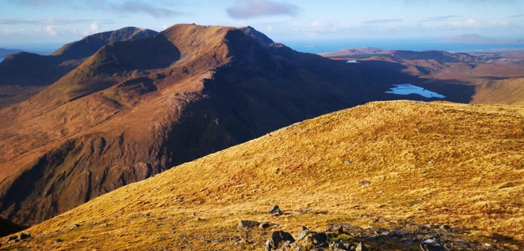
Once the summit has been reached, you’ll find yourself on a flat plateau which leads across a magnificent ridge line to Tievummera, which is safe to traverse, but would require caution during bad weather.
What makes the peaks iconic?
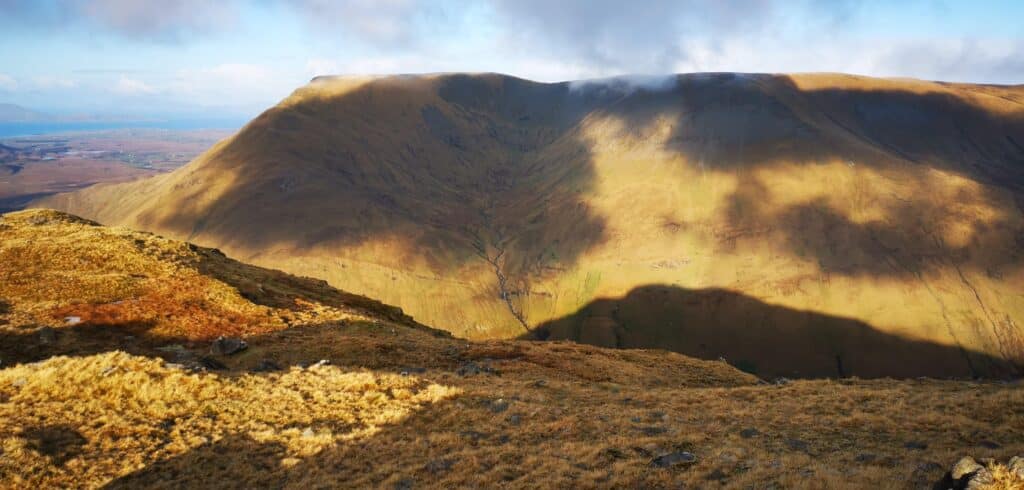
The infamous ridge line for starters. It connects the 2 peaks and once you have reached the summit of Barrclashcame from the Doolough side, make sure to continue and walk along. Many claim it to be one of Ireland’s most magnificent high mountain ridges.
A lesser known mountain range in Mayo, it’s a beloved spot for seasoned hill walkers. As with most peaks in the region, the Sheeffry Hills pose a good challenge.
Visually, what makes the Sheeffry Hills a unique range is the long flat summits which run for miles. This level plateau sharply contrasts with the steep slopes that descend on all sides, a terrain clearly shaped by glacial forces during the last ice age.
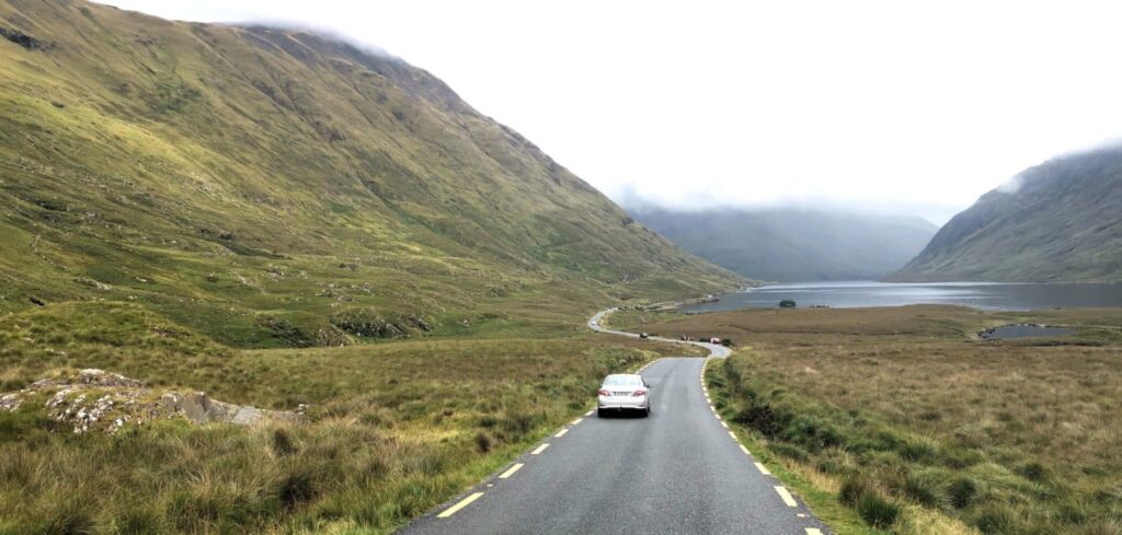
Below, to the left, you’ll see the ridge which leads to the summit of Barrclashcame (in cloud). This is the location for parking if ascending from the Doolough side.
Conclusion
All 5 of these Mayo mountains pose a significant challenge in their own respective ways. I would say the most accessible of all is Croagh Patrick, due to the fact that a well-worn path (now with steps) guides you hassle-free to the summit. In saying that, most people will regard it as a challenging climb.
And that also goes for the other 4 on the list. The final approach to all these peaks require optimal weather conditions, no fear of heights and a very good level of fitness and stamina. I will finish with one comment which a visitor to the county once made to me in a pub in Westport. He commented after climbing Croagh Patrick, Mweelrea and Croaghaun,
‘I totally underestimated these mountains. Not one reaches a height of even 1000 metres, but because there is no proper trails on most, you must have ideal weather and great navigational skills. But the fact that these mounatains are all located near the coast, it makes the climb so incredibly rewarding’.